Everest Three Pass Trek
Lukla, Phakding, Namche, Tengboche, Dingboche, Kongma La, Lobuche, EBC, Kalapatthar, Cho La, Gokyo, Renjo La, Thame
 Days
US$ 1575
Days
US$ 1575
Everest High Passes Trek overview
Everest, Nepal
Adventurous
5555m
March to May & Sept to Dec
Lodges / Hotels (B.L.D)
Everest three pass trek a most excellent trail in the Everest region and that is very much admired. The views of the incredible high Himalayan peaks are awe-inspiring. The best part of the Everest 3 pass trek is that it can be done in the anticlockwise as well as clockwise direction.
There are a lot of Buddhist monasteries, Chortens and Mani walls along the Everest high passes trekking route in Khumbu that are really striking. Trekkers can benefit from exploring the homeland of Sherpa, villages and understand its rich culture.
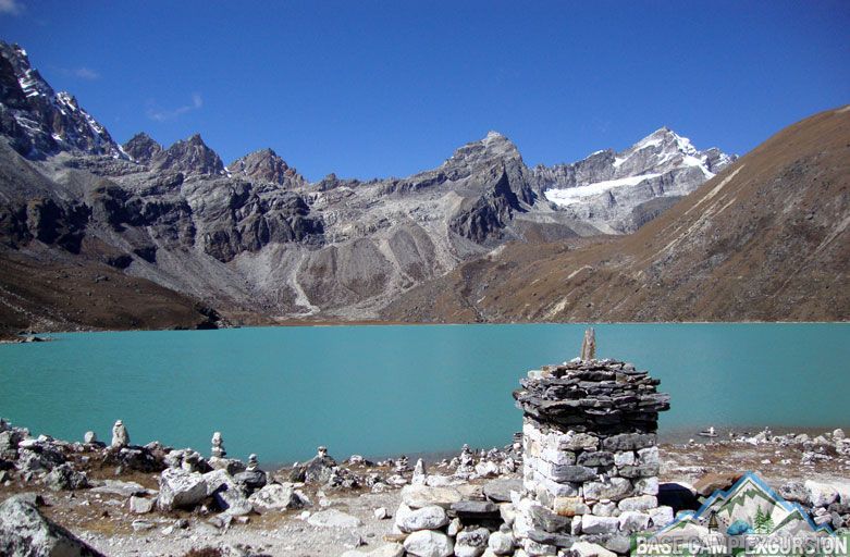
Everest high pass trek is known as the Everest circuit trek also. Trekkers cross three high pass Kongma La 5,535m, Cho La 5380m and Renjo La 5388m. In the same walking holiday trip travelers reach the Everest base camp 5360 m, Kala Patthar 5545m and Gokyo Lakes 4,790 meters also.
Everest high passes trek of Khumbu Himalayas categorized as a challenging trek. In high passes altitude the trekkers must be extra careful to avoid getting injured during Everest circuit trek. It is only best option in Everest for experience hikers or climbers to discover all corners of Khumbu region in single trip.
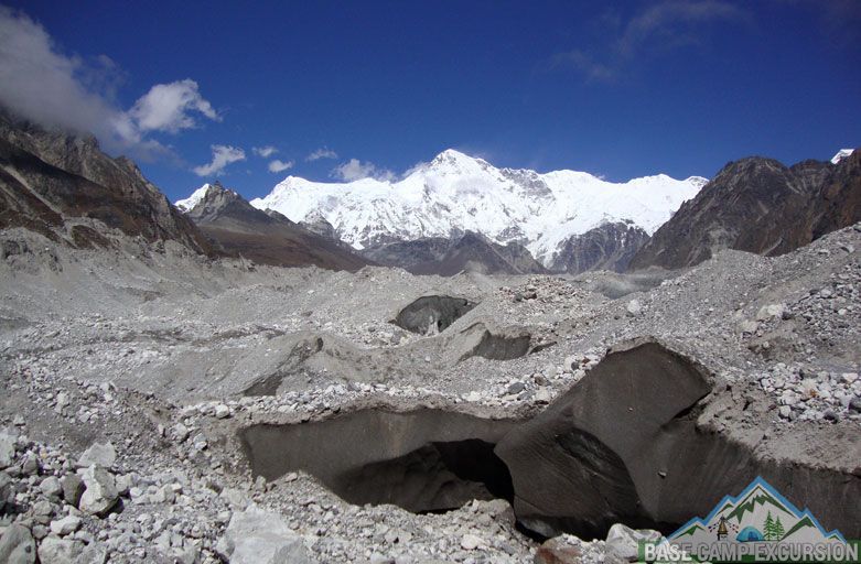
Crossing the Khumbu glacier and Ngozumpa glacier by walking offers stunning view of EBC, Khumbu ice-fall and mount Cho Oyu and longest glacier in the Himalayas.
The Everest three pass trek is the embodiment of real trekking experience in Nepal. It is necessary that you have to have a professional guide and support staff to make this trip success. There are a lot of places which are in the isolated parts of the Himalayas.
Exploring such isolated corners of Himalayas is an amazing experience. Tea house facility available along Everest 3 pass trail but it can be enjoyed as a camping trek too. Guide and support staffs are necessary by the side of the trekkers.
Everest three pass trek cost in us dollar for foreigners per person basic
Everest circuit trek full board package cost US$: 1575
Service package cost US$: 665 (guide, porter, permit, bed, pickup and drop)
We are Khumbu region specialized tour operator Nepal; organize the trekking according to the preference of the trekker write us to get quote.
Around Everest circuit trek to conquer EBC, Gokyo lakes & 3 passes
Mount Everest circuit trek is a gorgeous path to travel around Mount Everest the highest mountain in the earth. Three high passes of Everest, diverse landscapes and Sherpa culture along walking route give the tourists a first-hand experience of Nepali culture and way of life. Around Everest circuit journey connect Kongmala pass, Everest base camp, Kalapatthar, Chola pass, Gokyo lakes, Gokyo ri and Renjo la pass. It means you get an opportunity to explore all corners of Khumbu region at once.
Thrilling Mt Everest circuit trek is the longest trekking route of Everest area. it takes 18 to 22 days covering many beautiful destinations along this course. Entire route decorated with wonderful scenic beauty of Himalayan ranges with glaciers, passes, lakes and the lush greenery along the mountain slopes.
Professional guides lead you on arrival day in Kathmandu to departure from Nepal. Mount Everest circuit trek begins with Lukla flight from Kathmandu like other trips to Everest. While walking all the way through difficult mountainous paths trekkers love the thrill, joy, and awe that revolves around Everest circuit trek.
Rest day at Namche and Dingboche help to acclimatize properly to cross Kongma la then proceed Everest base camp & Kalapatthar. Crossing Chola pass connect EBC with Gokyo valley after huge Nagozumpa glacier. It is a wide valley with the breathtaking scenic beauty of the blue lakes amidst the snow-laden mountain peaks Cho Oyu & more. After reaching the ultimate destination of Everest circuit, trekkers cross Renjo la then walk downhill towards Lukla via Thame village.
Everest Kongma la pass trek across beautiful Chhukung valley Nepal
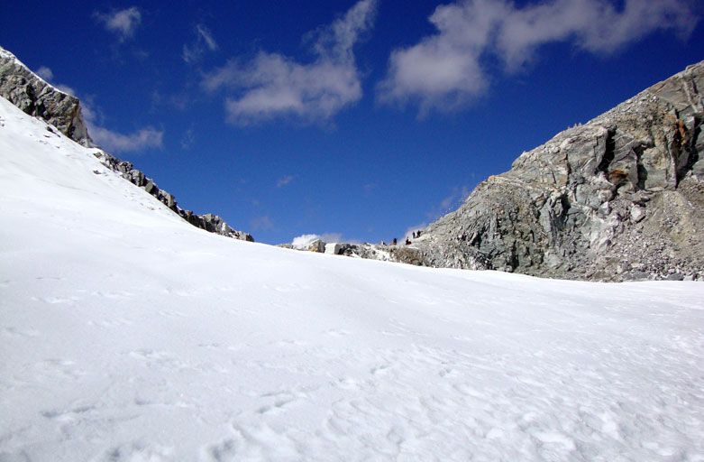
Kongma la pass 5536 meters / feet is the highest pass among the popular 3 passes of Mount Everest trekking region. It is not frequent route but really unique to observe the high mountain vistas. It is challenging trekking route, recommended for experience hikers and advise to do during the best time of year i.e. spring and autumn season.
You have to be careful while descending towards Lobuche village from the top of Kongma la. Rocky and icy track in cliff really difficult to decent. Challenging Everest Kongma la pass trek connect the Chhukung and Lobuche village situated at the bank of Khumbu glacier.
From the top of the pass trekkers see the eye catching view of the Thamserku, Ama dablam, Kongtega, Makalu Lhotse, Lobuche, Tabuche, Cholatse, Pumori and numerous peaks and glacial Lakes closely. Kongma la pass trekking provide you an opportunity to observe all natural and cultural beauty. You will trek through pine forest to alpine desert crossing Sherpa villages & enjoying the beautiful scenery.
Everest Kongma la pass trek is a combined trip with Everest base camp and Kala Patthar exploration at the same time. Mountain view during this journey is absolutely breath taking. If you have time and energy you can come back via gokyo valley after observing major places of Khumbu.
Walking through the Everest Kongma la pass route can be an experience of a life time as long as you book the right tour guide for the journey.
Guide for Renjo La pass elevation, map, difficulty and images
Renjo la pass elevation is 5345 meters, 17,536 feet above sea level. It is easier pass than other two passes of Everest region Cho la and Kongma La. Trekking trail is easy and wide, caravan of Yaks also can cross Renjo la pass. But it is still adventurous; difficulty level of this trek is fairly strenuous, painless to cross throw Gokyo valley.
If you would like to trek throw Thame village it is tough and long uphill walk. If you are planning to cross Renjo la no need to climb Gokyo Ri. Recommended to walk east to west direction to get the better and easy experience.
Top of the Renjo la pass, Gokyo Lakes and Gokyo Ri are the highlights of Renjo la trek or Everest three pass trek offers fascinating view of high mountains Nepal. Exclusive journey throw less crowded route the Gokyo Renjo la pass trekking is a thrilling experience in Khumbu Himalayas. Renjola pass offers the bets views of several Himalayan peaks including the best sight of Makalu and Mount Everest.
Those who undertake the journey through the Everest region via Renjo la can enjoy the amazing experience about the great Sherpa culture. They learn about the Sherpa lifestyle and taste their cuisine, religion, heritage and settlement of the ethnic villagers.
We have been operating Everest renjo la trek throughout the year with customize packages as per guest’s request. To make your dream for Everest come pleasingly true, please contact us immediately. We are also open to answer your any queries on the matter.
Trekking to Cho La pass elevation, map, difficulty and photos
Cho la pass elevation is 5,420 meters, 17,782 feet above sea level. Crossing Cho la pass of Everest region is not easy task. It is challenging trek difficulty level of this trek categorized in moderate and fairly strenuous. Both options are available to cross Chola pass either clockwise or anti-clockwise. Many tourists feel easy to cross this pass after Everest base camp and Kalapatthar trek.
The immaculate vista of mountains such as Everest, Lhotse, Nuptse, Makalu, Pumori, Ama Dablam, Cholatse, Thamserku, Kantega, Tawache, and others will treat you throughout the journey.
The natural treat of the trail can be relished with the exploration of verdant meadows, roaring rivers, quaint Sherpa villages; colorful stone craved houses, and eye-popping valleys of the region. Believe us, this journey is so endearing and rewarding that it can end up being the journey of your lifetime.
It is highly recommended to trek with professional trekking guide to make successful adventure. Chola connect the major highlights of Khumbu area like Everest base camp and Gokyo Lakes. Contact us to book Sherpa Guide for Chola pass trekking in Nepal.
Gokyo lakes Cho la pass trek to Everest base camp Nepal
Everest High Passes Trek highlights
Everest High Passes Trek itinerary
Get in touch with our travel experts to customize this trip within 5 minutes, that matches your interests.
- Airport pickup on arrival day by private vehicle
- 2 Night hotel in Kathmandu BB (1 night before-a night after trek)
- Airport transfer to go to airport for Lukla flight and back
- Round trip flights Kathmandu/Manthali – Lukla – Kathmandu
- 3 meals (BLD) +3 cups of hot drinks each day on choice during trek
- Best lodge accommodation during trekking period twin sharing basic
- English-speaking guide trained by Government of Nepal
- Highly experience staffs (2 guests: 1 porter basic)
- All necessary permits (SNP and PLRM) & local tax
- Transfer to airport to back home after Everest trip
Get a free consultation from destination experts, schedule a meeting or chat with us on WhatsApp.
Exclusive Trip - You May Like